
Set atop a 240-foot volcanic plug where the River Leven meets the River Clyde, Dumbarton Castle commands one of Scotland’s most dramatic defensive positions. Its recorded history goes back 1,500 years. The twin peaks of basalt—the Beak and the White Tower Crag—rise sharply above the town of Dumbarton. They offer sweeping views across the Firth of Clyde, Loch Lomond and Argyll. From Dark Age citadel to medieval royal refuge and Georgian garrison, this fortress witnessed the most turbulent chapters of Scottish history.
Plan your visit to Dumbarton Castle
Thu–Fri Closed
Sat–Sun 10:00–16:00Apr–Sep daily 9.30am–5pm; Oct–Mar Mon–Wed & Sat–Sun 10am–4pm (closed Thu–Fri); closed 24 Dec–4 Jan
Location of Dumbarton Castle
The castle sits at the end of Castle Road, beside the River Clyde in the south of Dumbarton, in West Dunbartonshire. It lies roughly 14 miles northwest of Glasgow. The castle sits 0.7 miles from Dumbarton East and a 1 mile from Dumbarton Central. Direct trains to Dumbarton East run from Glasgow Queen Street (30 mins), Livingston North (90 mins) and Edinburgh Waverley (110 mins). Direct buses to Dumbarton also run from Glasgow (60 mins), Helensburgh (25 mins) and Balloch (30 mins). The town centre lies within easy walking distance. Small car parking sits beside the castle entrance off the A82, though visitors should prepare for over 500 steps to reach the summit fortifications.
History of Dumbarton Castle
The first known accounts refer to it as Alt Clut, meaning “Rock of the Clyde”. Later it became known by the Gaelic name Dun Breatann (“Fortress of the Britons”) from which the name Dumbarton derives. From the 5th century the Rock stood as capital of the Kingdom of Strathclyde, controlling southwest Scotland. The vast Dark Age castle defended against the area’s ongoing Viking attacks. One such attack came in 870 when Viking kings Olaf and Ivar of Dublin filled the River Clyde with 200 longships. The Vikings breached the fortress after a siege, capturing hundreds and ending its role as the ancient capital.
Alexander II of Scotland built the medieval castle around 1220 as a defence against the threat from Norway. Norwegian kings ruled the Hebrides and the islands in the Clyde, just 10 miles downriver. In 1238 the castle becomes a royal castle. After the Battle of Largs in 1263 removed the Norwegian threat, Dumbarton transformed from frontier fortress to royal postern. It became a secure gateway through which Scottish monarchs could escape by sea. Edward I of England captured the castle in 1296, but the Scots wrested it back after Sir William Wallace’s victory at the Battle of Stirling Bridge (1297). The castle’s constable later captured Wallace himself in 1305. The castle sheltered both David II (in 1333–4) and Mary Queen of Scots (in 1548) until ships could take them to France and safety.
In 1489, James IV laid siege to the castle twice to remove its rebellious keeper, John Stewart, Earl of Lennox. James eventually succeeded after royal guns travelled from Edinburgh Castle, including the mighty Mons Meg. A daring raid took place during the civil war which followed Mary Queen of Scots’ flight to England.
Current status
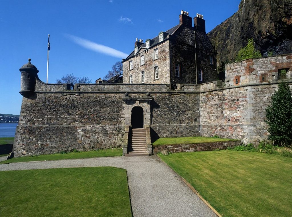
Historic Environment Scotland controls Dumbarton Castle, which welcomes visitors year-round as a staffed heritage attraction. Little survives of the medieval castle because most of it now dates to the 18th century. During that period engineers transformed the Rock into a formidable Georgian artillery fortress. Visitors climb through successive defensive layers, passing the Guardhouse, the French Prison and the Duke of Argyll’s Battery before ascending to the White Tower Crag. Enter the Governor’s House and explore the Rock of Ages exhibition, which features a fascinating collection of historic artefacts discovered at the castle. Highlights include a 1,000-year-old Viking sword pommel, medieval coins, and a replica of an embroidery panel created by Mary, Queen of Scots. The castle charges admission, though members of Historic Environment Scotland enter free.
The summit rewards those who conquer the ascent. Panoramas stretch across the Clyde estuary, south to the Renfrewshire hills, west towards Loch Lomond and the mountains of Argyll. They extend north along the river towards Glasgow. Far below, the confluence of the Leven and Clyde remains as strategic today as when ancient Britons first chose this rock for their stronghold. Wind sweeps across the barren peaks where cannon once stood guard. Jackdaws wheel above ramparts that have witnessed fifteen centuries of siege, escape and resistance.
Castles near Dumbarton Castle
Frequently asked questions
How difficult is the climb at Dumbarton Castle?
The castle requires climbing more than 500 steps on narrow historic stairways up a steep volcanic rock. The site is largely external and may close in poor weather, so wear suitable footwear and be prepared for an active visit.
Can I visit Dumbarton Castle without booking in advance?
While walk-up tickets may be available at the gate, Historic Environment Scotland recommends booking in advance to guarantee entry. Online tickets also offer the best value (£7.50 vs £8.50 for adults).
Is there parking available at Dumbarton Castle?
Free parking is available at the end of Castle Road near the castle entrance, though spaces are limited. Additional parking may be found at the nearby football ground or on neighbouring streets.
What can I see at Dumbarton Castle?
The castle sits atop a volcanic rock with views over the Clyde, Loch Lomond and Argyll. You'll find 18th-century fortifications, artillery displays, the Governor's House with exhibitions and shop, and the remains of one of Scotland's oldest strongholds dating back 1,500 years.
Is Dumbarton Castle suitable for visitors with limited mobility?
The castle is not wheelchair accessible due to the steep terrain and numerous narrow historic stairways throughout the site. All areas are reached by climbing stairs, making it unsuitable for those with mobility difficulties.
Featured listings